Sunday, August 26, 2012

TMB Day 1 - Les Houches to Les Contamines

Day 1 - Les Houches to Les Contamines via Clo de Tricot
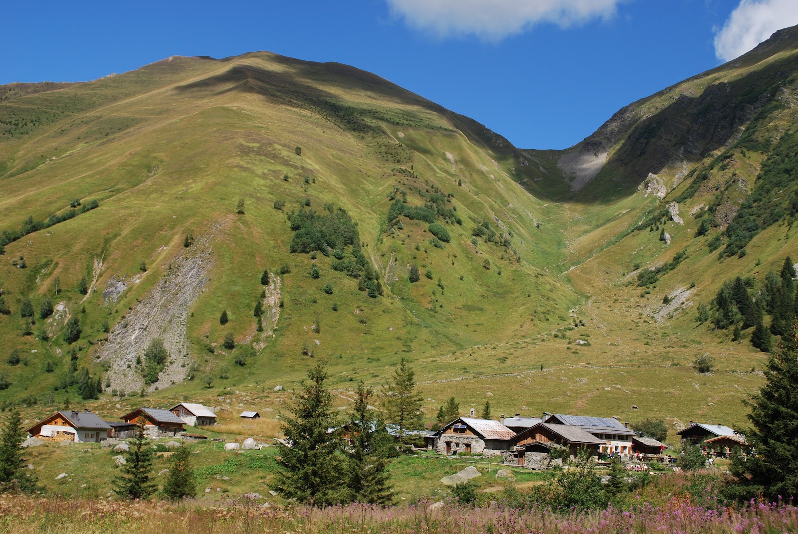
There were two options for today. The main TMB trail (which involved a fair bit of road walking and would go over the Col (pass) de Voza) or the TMB variante which would be very scenic but much more demanding. We woke up to low cloud cover over the mountains but the forecast was good, promising clear skies by mid-morning, so we opted for the variante. The scenery was awesome - suspension bridge over rushing glacial rivers, the Domes de Miage covered with snow and many glaciers. We stopped for an awesome lunch at Refuge du Miage. We don't regret taking this route but was it ever a togh climb and descent. We both think it was the most difficult day of hiking we've ever done. We gained about 1000m in height and dropped down over 1300 meters. We're pretty tired campers after day 1 and are all settled into the small Hotel du Clef des Champs in Les Contamines.  Hope we're not too sore in the morning.


We are headed towards the U shaped pass
Domes de Miage

We just came down this steep section from Col de Tricot to our lunch spot at Refuge du Miage


Another view of long descent


Church at Les Contamines

Saturday, August 25, 2012

TMB Starting point

Saturday, August 25
Arrived in Geneva an hour late but still managed to catch the twice-daily bus to Les Houches, a 2-hour drive away. Our hotel was an unexpected hike uphill from the centre of the village, but our room has a gorgeous view of Mont Blanc. Spent the afternoon walking around the village and feel surprisingly good despite the jetlag. A thunderstorm has moved in. Will be going to bed early and if the weather is good as forecast, we will set off tomorrow, a day early.
A few photos from Les Houches:


View from our balcony of Mont Blanc hidden to the right


Our hotel - Chalet Hotel Campanule


Les Houches village centre


View of Les Houches from our balcony


Also from our balcony

Monday, August 20, 2012

Tour du Mont Blanc

Well, we've wanted to do this hike since we finished the C2C in 2008. We're not getting any younger so it's best to take this on sooner than later. The Tour du Mont Blanc is a classic long distance walk in the Alps typically taking 7 to 11 days covering a distance of over 167km including 8000m of ascent. The route goes around the highest mountain massif in western Europe over high passes giving amazing views of the towns, glaciers and mountains as well as passing through alpine valleys, towns and villages. The TMB is a circular route that goes through three countries - France, Italy and Switzerland. We'll be walking about 100 miles and hope to do it in 9 days or so. We've decided not to pre-book accommodation, except for the first night, so that we can hike according to the weather and to how our bodies feel. We fly to Geneva on the weekend and from there travel to our starting point - Les Houches, France. The standard legs are as follows:
Start Destination Kilometer Hours Ascent Meter Descent Meter
Les Houches Refuge du Truc 12.8 km 4:59 1536 m 775 m
Refuge du Truc La Balme 11.4 km 3:10 544 m 601 m
La Balme Les Mottets 15.9 km 4:23 1166 m and up 1136 m
Col de Chercroui Courmayeur 5.78 km 1:20 88 m 796 m
Courmayeur Rifugio Bertone 4.12 km 1:47 727 m 0 m
Rifugio Bertone Rifugio Elena 19.5 km 5:06 1163 m 1086 m
Rifugio Elena Champex 28.2 km 7:44 1045 m 1656 m
Champex Le Peuty 13.6 km 6:01 1213 m 1274 m
Le Peuty Tre-le-Champ 15.7 km 5:25 1219 m 1108 m
Tre-le-Champ Refuge Flegere 7.99 km 3:18 855 m 413 m
Refuge Flegere Les Houches 19.6 km 6:25 889 m 1773 m
Total: 173.5 km 55 hours 11.603 Meter 11.895 Meter
 Here is a small map of the route:

Friday, April 6, 2012

The South Downs Way Day 3

This afternoon we hiked the section from Amberly westwards this time. Today was gorgeous and sunny and the views over the countryside were beautiful. We passed Bignor Hill and finished our hike at the village of Cocking, stopping at the Bluebell for a pint. The nice lady at the bar worked the phones, trying to get us a taxi on a Friday evening which proved a bit difficult and took some time. Over all, an enjoyable day.


Met a Scottish lad, wearing a kilt, who was doing the entire South Downs Way at a pretty good clip.


Thursday, April 5, 2012

The South Downs Way Day 2

We were staying near Arundel and so decided to hike the section from Amberly eastwards. Francine had a bad cold so we didn't get going till about 11 am. Drove to Amberly, parked the car and started walking. It was quite cool and very windy. We stopped to walk around the Chanctonbury ring - originally a hill fort built in the Iron age and which was also a Roman religious site at one time. The fame of the Ring, however, is due not to the hill fort but to the beech trees, which were planted in 1760 by Charles Goring within the earth bank of the fort, which we could still see today. The trees became a famous landmark, very thickly wooded, however, the Great Storm of 1987 destroyed most of the trees and the replanted trees are only now beginning to restore the ring to its former glory.  Afterwards, we walked as far as Steyning, only to find there was no bus to Amberly. Stopped at a pub for a pint and the owner, who also drove taxi, offered to take us back to our hotel.


Chanctonbury ring


Wednesday, April 4, 2012

The South Downs Way Day 1

Started off at Eastbourne at the east end of the trail. Beautiful chalk cliffs all along the coast. Since we still had our car, we hiked sections and drove on to others. Hiked along the estuary and back to get the best view of the Seven Sisters and then realized that we still had a two hour drive to get to Winchester to meet up with our friends Jonathan and Anne for dinner! Barely made it in time.


Cape at Beachy Head - the highest chalk sea cliff in Britain at 162 metres (531 ft) above sea level.


The Seven Sisters viewed from the east


Memorial cairn at Cuckmore Haven see: http://www.rclbr50.ca/news/item.asp?T=0&NID=-1032866338


The Seven Sisters