Friday, August 31, 2012

TMB Day 6 - Refugio Bonatti to La Fouly

TMB Day 6 - Refugio Bonatti to La Fouly

Word for the Day - Diversity
Sunshine, clouds, fog, mist, drizzle, rain, sleet, freezing rain, hail and snow - we saw it all today!

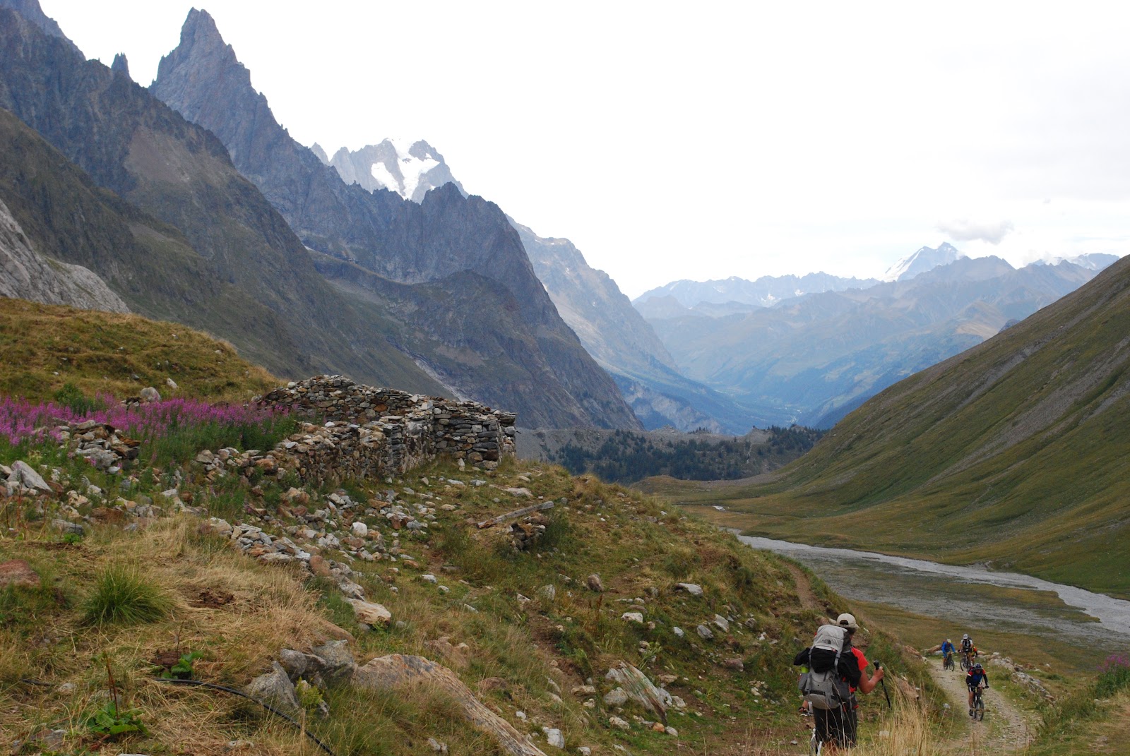
Woke to beautiful blue skies and clear views of Mont Blanc, however we knew it would not last.  Set off early, before 8, knowing we had a high pass to navigate and wanted to be ahead of today's Ultra Trail race (1200 racers from Courmayeur to Chamonix - half TMB in 10 to 16 hours).

The first hour was pleasant and level with great views to the valley below.  We were soon donning our rain gear for a major mucky descent and then ascent to Refugio Elena arriving in the driving snow.  A few hikers decied to stay there since we were at 2062m and we still had to climb to 2537.  After a coffee and a pep talk to Francine, we set off for the Grand Col Ferret.  We reached the pass in blinding snow and heavy winds after negiotiating steep and narrow trails at the edge of cliffs that had become snow covered.  Francine's hands were cold from the wet gloves she had as the temperature dropped at the top (-4C).  We didn't stay long and couldn't see anything so headed down the Swiss side of the mountain after learning that the first of the racers was about 10 minutes behind us.  He soon passed us as did a constant flow for the remainder of the afternoon.  Difficult hiking while watching for racers coming up behind us.  After the snow stopped on the Swiss side we actually had a pleasant descent to La Fouly.

Checked into Hotel Edelweiss and after a hot shower headed down for dinner with the folks from the UK and the US.  Tomorrow should be an easy day.
Mont Blanc - the day began with sunshine


At Grand Col Ferret - blinding snow!

 Ultra Trail CCC runners

Torben & Merete - Danes living in UK, Mark & Kathy from Minnesota

Thursday, August 30, 2012

TMB Day 5 - Courmayeur to Refugio Bonatti

TMB Day 5 - Courmayeur to Refugio Bonatti

Word for the day - Unpredictable

After seeing the 1200 runners leave Courmayeur at 7 AM, we had breakfast and set off ourselves at 9 AM in the pouring rain.  Needed to use our rain gear and pack covers that we had hoped we wouldn't have to.  We set off on a steep ascent for approximately 2 hours to Rufugio Bertoni.  Care was required as the trail was rocky and slippery and every so often, we would catch a glimpse of the mountain peaks, glaciers and the valley below.   By the time we arrived at Bertoni, we were soaked to the skin.  After hot coffee we set off again and fortunately the rain stopped and the skies cleared somewhat for what turned out to be a pleasant afternoon.  At 2 PM we arrived at Rufugio Bonatti,which was wonderful even if we didn't have our own room.  Just us and 4 Irish Lads.  This Rufugio was clean, modern and the food was excellent.  Chatted with Merete and Torben from the UK and Kathy and Mark from Minnesota. To bed early for a big day tomorrow.  Forecast is for snow above 2000 metres and we will be crossing a pass at 2537 m.
The start of one of the Ultra TMB races in  Courmayeur

Coming up to Refugio Bertone in the rain

Val Ferret

Inside Refugio Bonatti - the best Refugio on the TMB

Refugio Bonatti - our room was one of the two at the top

Wednesday, August 29, 2012

TMB Day 4 - Courmayeur

TMB Day 4 - Courmayeur
Word of the day - Restful.

After arriving in Courmayeur yesterday and settling into Hotel Berthoud, we walked the pedestrian streets of this lovely little village and had a wonderful Italian meal and a great nights sleep.

We spent the day today doing a bit of laundry, uploading photos for our blog at the Library and walking around town.  We bumped into a couple of the Australians (Margaret and Tahira) and ended up having a lovely dinner with them and John and Lynne. 

Back at Hotel Berthoud, a family owned hotel since 1960, we chatted with 3 generations of the family.

Another early night as we plan to get up early tomorrow to watch the start of one of the TMB races.  The most famous of the 4 Ultra Trail TMB races, consists of running the entire TMB curcuit (168 km´s) in 20 to 24 hours.  It will take us 10 days!
Courmayeur - what a setting this town finds itself in!

Our new friends from down under - Lynne, John, Tahira and Margaret

The wonderful ladies at Hotel Berthoud - 3 generations : Julia, Gabriella & Mrs Berthoud


Tuesday, August 28, 2012

TMB Day 3 - Les Chapieux to Courmayeur

TMB Day 3 - Les Chapieux to Courmayeur
Word for today - Perseverance!

Set off bright and early at 8:15 on another glorious day of clear skies, from Les Chapieux on the way to Refugio Elisabetta via Val des Glaciers.  Most hikers took a shuttle bus to Val des Glaciers, saving about 1.5 hours of hiking, but we chose not to.  We climbed up to Col des Seignes (2516m) and enjoyed spectacular panoramic views including our first clear look at Mont Blanc.  We were now crossing from France to Italy. Our plan was to end the day at Refugio Elisabetta, about a 5.5 hour journey and a relatively short day.  The hike to the Col des Seignes was tough for Francine - possibly the altitude and heavy pack that we are not used to.  Arriving at Refugio Elisabetta, we were shown our sleeping quarters which can only be described as 5 single mattresses all tightly laid side by side and we were expected to occupy one! That meant that there could be potentially 4 more couples sharing this bed space.  This might of been fun when we were 5 but not at 50.  Peter said that he hadn't signed up for this and convinced me and my tired body to keep going.  So we set off at 3 PM downhill to La Visaille (1.5 hours away) and hopped a quick bus ride to Courmayeur where we settled into the Hotel Berthoud and decided that tomorrow would be a rest day.
We would love to add more photos but they are very time consuming to download....
Note to Chris : Legs ok, but we have been through quite a few Advil!

Val des Glaciers


Our first view of Mont Blanc from Col des Seignes

Typical waymarker


Refugio Elisabetta

Monday, August 27, 2012

TMB Day 2 - Les Contamines to Les Chapieux

Day 2: Les Contamines to Les Chapieux
Word for today - excruciating

Woke to beautiful blue cloudless skies. Set off from Les Contamines (1167m) for what turned out to be 6 hours of straight up climbing, very steep throughout. We hiked up to the Col du Bonhomme (2443m) passing through a section of snowpack. then on up some more to the Col de la Croix du Bonhomme (2483m) getting there at 4 pm knowing that we still had over 2 hours of descent left to do. Thank God we each bought another hiking stick this morning - don't think we would have made it without them. The scenery today was spectacular, not a cloud all day. We met a lovely couple , John and Lynne from Sydney, Australia and walked the final portion of the day with them. We arrived at the Auberge de la Nova in Les Chapieux just in time for a quick shower then down to communal dinner at 7. What a long day! Peter wasn't crazy about our accommodation - we were in a 6 bed dortoir - 3 sets of bunk beds and since we arrived last we were stuck on top. Our roommates were already in bed at 9 when we went up after dinner so we had to rummage in the dark to settle in. We didn't sleep all that well in spite of being dog-tired.

Notre Dame de la Grotte, shortly after leaving Les Contamines

On the way up to Col du Bonhomme. Walking through the snow was more difficult!
Village of Les Contamines is in the far distance

At Col du Bonhomme

View to the other side of Col du Bonhomme

Knee wrecking descent to Les Chapieux

Sunday, August 26, 2012

TMB Day 1 - Les Houches to Les Contamines

Day 1 - Les Houches to Les Contamines via Clo de Tricot
There were two options for today. The main TMB trail (which involved a fair bit of road walking and would go over the Col (pass) de Voza) or the TMB variante which would be very scenic but much more demanding. We woke up to low cloud cover over the mountains but the forecast was good, promising clear skies by mid-morning, so we opted for the variante. The scenery was awesome - suspension bridge over rushing glacial rivers, the Domes de Miage covered with snow and many glaciers. We stopped for an awesome lunch at Refuge du Miage. We don't regret taking this route but was it ever a togh climb and descent. We both think it was the most difficult day of hiking we've ever done. We gained about 1000m in height and dropped down over 1300 meters. We're pretty tired campers after day 1 and are all settled into the small Hotel du Clef des Champs in Les Contamines.  Hope we're not too sore in the morning.


We are headed towards the U shaped pass
Domes de Miage

We just came down this steep section from Col de Tricot to our lunch spot at Refuge du Miage


Another view of long descent


Church at Les Contamines

Saturday, August 25, 2012

TMB Starting point

Saturday, August 25
Arrived in Geneva an hour late but still managed to catch the twice-daily bus to Les Houches, a 2-hour drive away. Our hotel was an unexpected hike uphill from the centre of the village, but our room has a gorgeous view of Mont Blanc. Spent the afternoon walking around the village and feel surprisingly good despite the jetlag. A thunderstorm has moved in. Will be going to bed early and if the weather is good as forecast, we will set off tomorrow, a day early.
A few photos from Les Houches:


View from our balcony of Mont Blanc hidden to the right


Our hotel - Chalet Hotel Campanule


Les Houches village centre


View of Les Houches from our balcony


Also from our balcony

Monday, August 20, 2012

Tour du Mont Blanc

Well, we've wanted to do this hike since we finished the C2C in 2008. We're not getting any younger so it's best to take this on sooner than later. The Tour du Mont Blanc is a classic long distance walk in the Alps typically taking 7 to 11 days covering a distance of over 167km including 8000m of ascent. The route goes around the highest mountain massif in western Europe over high passes giving amazing views of the towns, glaciers and mountains as well as passing through alpine valleys, towns and villages. The TMB is a circular route that goes through three countries - France, Italy and Switzerland. We'll be walking about 100 miles and hope to do it in 9 days or so. We've decided not to pre-book accommodation, except for the first night, so that we can hike according to the weather and to how our bodies feel. We fly to Geneva on the weekend and from there travel to our starting point - Les Houches, France. The standard legs are as follows:
Start Destination Kilometer Hours Ascent Meter Descent Meter
Les Houches Refuge du Truc 12.8 km 4:59 1536 m 775 m
Refuge du Truc La Balme 11.4 km 3:10 544 m 601 m
La Balme Les Mottets 15.9 km 4:23 1166 m and up 1136 m
Col de Chercroui Courmayeur 5.78 km 1:20 88 m 796 m
Courmayeur Rifugio Bertone 4.12 km 1:47 727 m 0 m
Rifugio Bertone Rifugio Elena 19.5 km 5:06 1163 m 1086 m
Rifugio Elena Champex 28.2 km 7:44 1045 m 1656 m
Champex Le Peuty 13.6 km 6:01 1213 m 1274 m
Le Peuty Tre-le-Champ 15.7 km 5:25 1219 m 1108 m
Tre-le-Champ Refuge Flegere 7.99 km 3:18 855 m 413 m
Refuge Flegere Les Houches 19.6 km 6:25 889 m 1773 m
Total: 173.5 km 55 hours 11.603 Meter 11.895 Meter
 Here is a small map of the route: